He called the place “una laguna graciosa“, but there are those who suspect this soldier with the Portola Expedition remembered not so much the small lake and its excellent drinking water, as the Indian maidens who danced gracefully upon its shores. Ten years later, when the Anza Expedition camped in the same location, Father Pedro Font wrote that La Laguna Graciosa was “small and of very fine water”.
Small the lake must have been, for it is gone today. Yet La Laguna Graciosa was an important water source at the time, for all of the early Spanish expeditions camped on its shores, and the Indians visited frequently. Fresh water was plentiful along the Central Coast in those early days, but one needed to know where to find it. When William H. Brewer traveled through northern Santa Barbara County in 1860 with the U.S. Geological Survey he wrote, “…there is only water at the ranches, at intervals of six to ten miles on an average.” The prudent traveler set a course by the location of potable water.
Where, then, was this beautiful lake of fine water that so moved Portola’s men? The next mention of La Graciosa this researcher found was in 1824. The reference is not to a lake but to a ridge called Cuesta de la Graciosa in the Solomon Hills, a range of low hills that separate the Los Alamos Valley to the east from the Santa Maria Valley River system to the west. The ridge identified as Cuesta de la Graciosa runs west from the flat-topped Mount Solomon to a low area in the hills where Route 135 and La Graciosa Road travel between Los Alamos and Orcutt. An 1840 diseño refers to this valley as Cañada de la Graciosa or La Graciosa Canyon. In the early 1860’s a stage stop was established in the western part of this canyon. It was named La Graciosa. From it grew a town with the same name.
It is easy to understand how the name proliferated in the region once it gained a foothold. But is this valley the place where the Indian maidens danced for Portola’s’ men by the rippling waters of a lovely lagoon? No one seems to be quite sure.
Portola’s journey is well documented. Three of the expedition members kept journals: Miguel Costansó, Frey Juan Crespi, and Gaspar de Portola himself. Portola’s entries tended to be stilted and brief compared to the flowing prose of Frey Crespi, while Costansó finds a middle ground. The entries of the three men do not always agree. In fact, when Portola named a location or a feature in his journal, Frey Crespi invariably renamed it, usually for the saint of the day. But all three journals agree on one important point, and that was the compass direction the expedition traveled. They all agree that from the mouth of the Santa Ynez River the expedition traveled due north.
In an exploratory expedition such as this, it was essential to maintain an accurate record of daily compass settings to enable members to retrace their steps and to guide those who would follow. The expedition navigators must pay the utmost attention to compass accuracy, and would certainly allow for longitudinal compass deviation and similar details. The course of the expedition from the Santa Ynez River to the fresh water lagoon where they camped cannot be in doubt. It was due north. Yet a due north compass setting does not take one to La Graciosa Canyon or La Graciosa Ridge. It takes a route well west of that area.
If Portola’s laguna was not in the valley later named La Graciosa, where was it? Miguel Costansó wrote, “We set out from the Río de San Verardo (Santa Ynez River) in the morning, and traveled for two leagues towards the north over level ground…” *
Fray Juan Crespi wrote “Early in the morning we set out from this river, traveling directly to the north, over sand dunes and shells, which we soon left behind and went through level country with low hills. After three hours travel, during which we must have covered two leagues and a half, we arrived at the camping place…”
Unfortunately, there is no entry for this day in Portola’s diary. Both Costansó and Crespi estimate the distance traveled that day at two to two and a half leagues. A league is commonly known to be the distance a man can walk in an hour. The terrain will influence that distance, of course.
By the time the expedition had arrived at the Santa Ynez River mouth, they had traveled many days, and one can assume that the members had an accurate idea of the length of a league. I decided to take advantage of this fact. I looked back in the journals and found the number of leagues between two known points of their prior travel, and determined a fixed distance that was the chroniclers’ shared idea of a league.
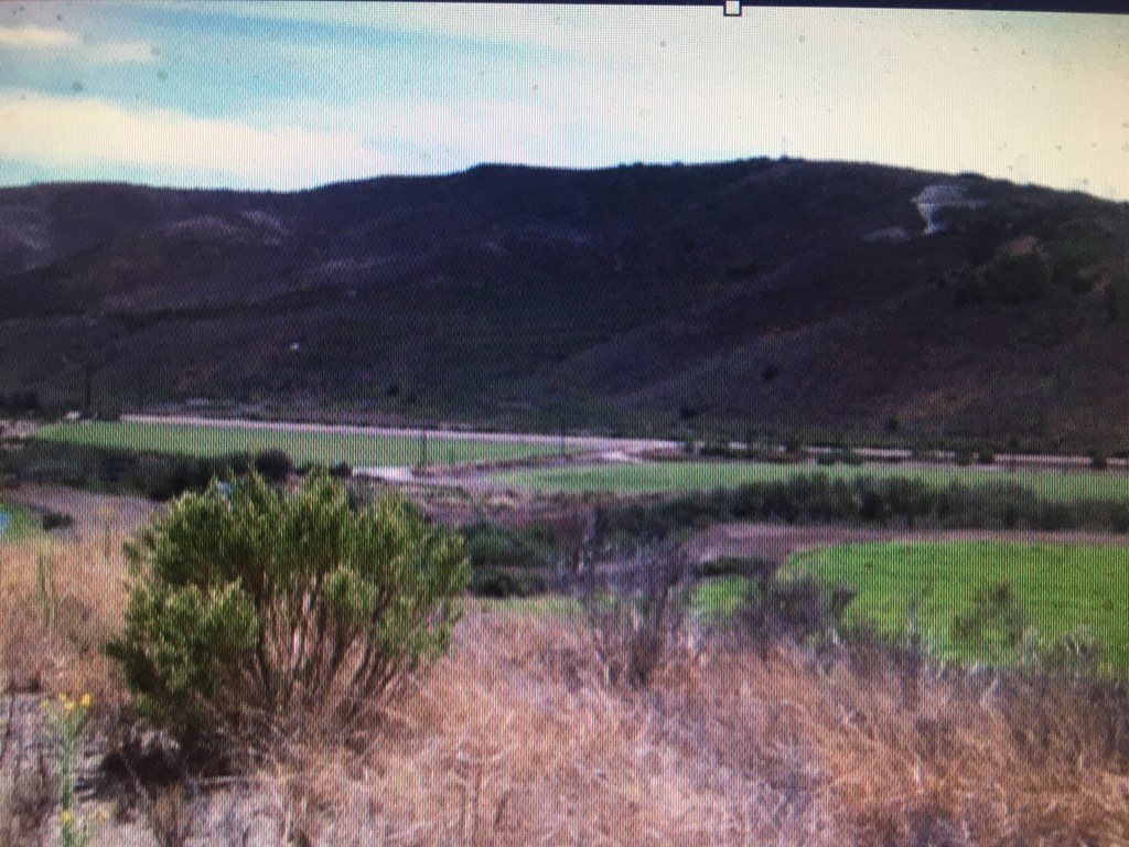
Armed with this knowledge and a topographical map, I drew a line due north from the mouth of the Santa Ynez River the estimated equivalent of two and one half leagues. My line terminated in the valley of San Antonio Creek, not far from where it empties into the Pacific. There is no lagoon there now, but viewed from above (with the help of Google), the flat fields around the creek form the outline of a long, slender lake. The topography fits Crespi’s description: “It is in a hollow, surrounded by hills, not very high.” Although the lagoon itself has long since dried up, I believe this to be the place called Ranchería del Baile de las Indias, the place where the Indian maidens danced.
Then how did a valley and a ridge more than a mile east come to have the same name, La Graciosa? The original expedition did not travel that way. After their camp at La Graciosa Laguna, the next significant landmark for the Portola Expedition on the way north was Laguna de Guadeloupe, a large lake in the Santa Maria Valley east of the present town of Guadeloupe. That lake no longer exists, but it did until recent memory, and found its way onto maps well into the 19th century.
As explorers and settlers spread east into the valleys and hills, El Camino Real, the primary route north, shifted east as well. By then, the original La Graciosa Laguna was gone and that part of the San Antonio Creek valley was bypassed. Now travelers came to know the area further east as La Graciosa where a stage stop was placed.
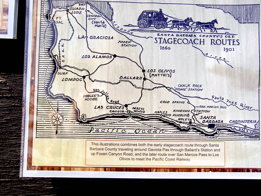
There were indeed lakes around La Graciosa Canyon, and the stage stop soon grew into a town. A former resident of the town wrote that it was a beautiful place, the “lakes teeming with waterfowl, including swans” and plentiful deer and other wildlife. In fact, there were many lakes in the region. The diseño for Rancho Punta de Laguna and the one for Rancho Jesus Maria have multiple lakes drawn on them. None of these lakes exist today. But at the time the stage stop was constructed, they were there. The transference of the name La Graciosa from the lagoon of the dancing maidens to this region of lakes to the east must have seemed natural.
As always, we welcome comments or notes related to our research. RLG
